Stage 42. Valkenburg a/d Geul (NL) to Margraten (NL)

Stage 42. Valkenburg a/d Geul (NL) to Margraten (NL)
Around the middle of the 19th century a new source of income developed in the mainly agriculturally oriented Valkenburg aan de Geul; tourism. The opening of the Aachen – Maastricht railway line in 1853 with a Valkenburg aan de Geul station (the oldest railway station building in the Netherlands that still is in use) was an important step towards opening of the relatively isolated Valkenburg aan de Geul.
Margraten is international known by the presence of the Netherlands American Cemetery and Memorial, a large military cemetery. After WW2 the Dutch government gave US the land on which this cemetery is located for eternally in use as respect and gratitude. There are 8302 soldiers buried. However, there are only 8301 graves because in one grave are two unknown fallen American soldiers.
Overview map and stats:

| Start: | Valkenburg aan de Geul (NL) |
| Coordinates (DD): | 50.864595 / 5.832476 |
| End: | Margraten (NL) |
| Coordinates (DD): | 50.820220 / 5.821608 |
| Distance: | 21,3 kilometers |
| Ascent: | 293 meters |
| Descent: | 191 meters |
| Elevation map: |

| Path, dirt road, nature trail: | 76% |
| Asphalt, road: | 24% |
| Pdf route map: | Go for download to page here |
| Gpx track: | Go for download to page here |
| KML file: | Go for download to page here |
- Pdf files are excellent for viewing.
- Gpx tracks can be uploaded to many devices, so you always know the direction to follow or your position.
- KML files can be uploaded in Google Earth. As result you get a detailed satellite view. You can even follow a videotour, which is a linear walk-through the stage.
Some highlights:
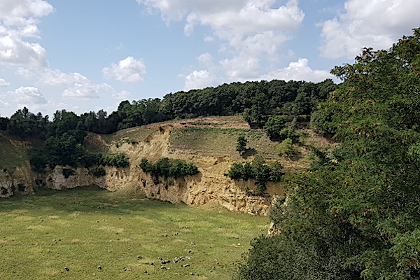

This almost 40 hectare Curfsgroeve (quarry) dates from 1930. Marl was mined. After the marl extraction ended in 2009, the quarry was given a nature destination. The area is home to a very rich and special flora and fauna. The quarry is especially important for wild bees. All kinds of fascinating processes also take place, such as small collapses, landslides and the creation of alluvial fans and small wells. The spectacular part of the quarry can be clearly seen via a walking route on the north side.
